Showing 1129 items matching documents - maps
-
 Federation University Historical Collection
Documents and maps, Holmes - Documents, Letters, Family Trees, Maps
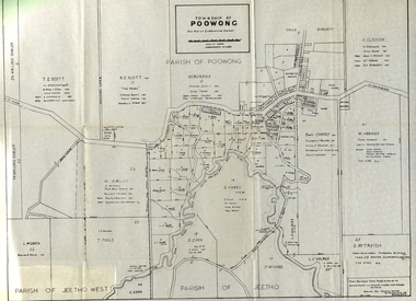
... Documents and maps...Holmes - Documents, Letters, Family Trees, Maps... Documents and maps Holmes - Documents, Letters, Family Trees, Maps ...elizabeth mary holmes, ascot residence tender notice, family tree, map of poowong township -
 Warrnambool and District Historical Society Inc.
Documents Maps (3) - Warrnambool Town Allotments, City of W'bool Parish of Wangoom Country of Villiers, 1948
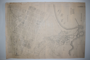
... Documents Maps (3) - Warrnambool Town Allotments ... Street (south of Merri St) Warrnambool great-ocean-road Documents ...These maps were produced in 1948 and they contain maps of allotments within the city of Warrnambool, including the Central Business District, up to 1948. The details given on each allotment show the allotment and section numbers, the measurement in acres, the name of the original purchaser of the lot and the date of the first sale. The Warrnambool and District Historical Society owns several copies of these maps but these ones are originals.These three maps are of great significance because they give the names of land purchasers in Warrnambool from the date of the first land sales in 1847. They are a most valuable research tool and can be scanned and photocopied etc.These are three sheets of cream paper pasted on to linen. The sheets have black and white printing and map work. Some of the edges are a little frayed and there is some staining, particularly on the backs of the sheets.‘City of Warrnambool Parish of Wangoom County of Villiers Sheet 1’ ‘City of Warrnambool Parish of Wangoom County of Villiers Sheet 2’ ‘City of Warrnambool Parish of Wangoom County of Villiers Sheet 3’city of warrnambool, warrnambool maps, warrnambool town allotments 1948, land purchases -
 Clunes Museum
Map - MAPS/ DOCUMENTS, CIRCA 1857
... MAPS/ DOCUMENTS...COLLECTION OF DOCUMENTS (COPIES OF10 MAPS AND DIAGRAMS...MAPS/ DOCUMENTS Map COLLECTION OF DOCUMENTS (COPIES OF10 ...COLLECTION OF DOCUMENTS (COPIES OF10 MAPS AND DIAGRAMS OF TOURAAL PURCHASED UNDER PREEMPTIVE RIGHT BY DONALD CAMEROM 17TH FEBRUARY, 1857. COUNTY OF TALBOT - GOLDFIELD'S SURVEY PLAN NO.1 CLUNES COUNTY OF TALBOT. GLENDONALD - CRESWICK/CLUNES.local history, mining -
Clunes Museum
Map - MAPS / DOCUMENTS
... MAPS / DOCUMENTS...MAPS / DOCUMENTS Map .1 MAP OF CRESWICK CLUNES - 45 MINES ....2 WAS MADE 1859.1 MAP OF CRESWICK CLUNES - 45 MINES NAMED IN CLUNES .2 DEPT. OF MINES SHOWING CLUNES - ENLARGEMENT - 100 IN CRESWICK, CRESWICK AND MCDONALD AND CO PREEMTIVE PURCHASE INDEXES OF QUARTZ AND A;LLUVIAL MINE LOCATIONS .3TOPHOGRAPHICAL MAP REF GF 23 CLUNES, MT GREENOCK TALBOT.1 360 SCALE 1 : 2500 .2 303/59 33 RECEIVED 15 OCTOBER 1859 SIGNED R. BROUGHTON, JAMES STEVENSON DISTRICT MINING SURVEYOR .3 40 CHAINS TO AN INCH mine sites, department of mines, creswick, clunes -
Clunes Museum
Map - MAPS/DOCUMENTS
... MAPS/DOCUMENTS...MAPS/DOCUMENTS Map DOCUMENTATION AND MAPS DESCRIBING ...INFORMATIONDOCUMENTATION AND MAPS DESCRIBING THE WORKINGS OF THE PORT PHILLIP MINE, SHOWING 54 FEET DEEP OF THE UNDERGROUND WORKINGS.local history, mining, port phillip mine -
 Phillip Island and District Historical Society Inc.
Photograph, Bryant West, 1798
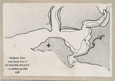
... exploration maritime documents maps george bass phillip island bryant ...One of a collection of over 400 photographs in an album commenced in 1960 and presented to the Phillip Island & Westernport Historical Society by the Shire of Phillip IslandPhotograph of the First Map of Phillip Island ever drawn. An eye sketch by Bass.As written on front of map - "Western Port on the South Coast of Nw. South Wales from GE Bass's Eye-sketch 1798"local history, photography, photographs, exploration, maritime, documents, maps, george bass, phillip island, bryant west, john jenner -
 Phillip Island and District Historical Society Inc.
Photograph, Bryant West
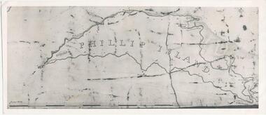
... maritime documents maps exploration john jenner bryant west phillip ...One of a collection of over 400 photographs in an album commenced in 1960 and presented to the Phillip Island & Westernport Historical Society by the Shire of Phillip IslandPhotograph of an early Map of Phillip Island not drawn to scale. Copy from Records Office, London.On back of photo - "If used must bear acknowedgement - reproduced by permission of the Hydrographer of the Navy" "Received 18/3/1955 from London Records Office per Mr mcGrigor-Phillips" Printed on Map "Phillip Island"local history, photography, photographs, maritime documents, maps, exploration, john jenner, bryant west, phillip island map -
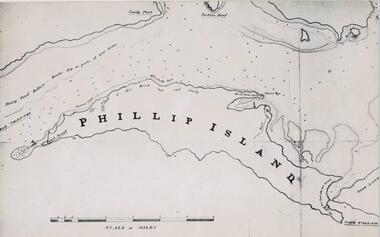 Phillip Island and District Historical Society Inc.
Photograph, Bryant West
... documents maps phillip island john jenner bryant west Bryant West ...One of a collection of over 400 photographs in an album commenced in 1960 and presented to the Phillip Island & Westernport Historical Society by the Shire of Phillip IslandPhotograph of a Map of Phillip Island. The first to show Fort Dumaresq, track to beach and beginning of road to South coast. local history, photography, photographs, exploration, maritime, documents, maps, phillip island, john jenner, bryant west -
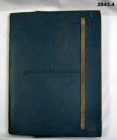 Bendigo Military Museum
Administrative record - FOLDER, 2) & .3) Geographical Section, General Staff, No 4080 War Office 1941 et al, Navigator's Log Book, 2) & .3) 1941
... documents - maps/records...: Mediterranean. Blue & red ink numerous notations over map. documents ....1) Navigator's Log Book, hard cover, blue colour buckram with dark blue paint on front cover. Back end paper includes a pocket for maps & has a Conversion Table & Nautical Miles, Statute Miles, Kilometres, tables in black print on beige paper included. Stiff card divider. .2) Map folded, black printing on beige paper. Gibraltar Scale 1:1,000,000 at 56 degrees N. .3) Map folded, black printing on beige paper. Algeria Scale 1:1,000,000 at 56 degrees N. .4) Pencil grey lead, timber colour. Stamped into pencil: HB Commonwealth of Australia..1) Hand written in black ink on front end paper: Wreck at Cape Juby. In pencil: S2 / MZ / W2 / 1Z . 35N .2) Hand written in blue pencil: Atlantic. Blue & red ink & lead pencil notations over map. .3) Hand written in blue pencil: Mediterranean. Blue & red ink numerous notations over map.documents - maps/records, military history, passchendaele barracks trust -
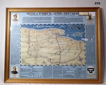 Bendigo Military Museum
Map - MAP, FRAMED, Siege of Tobruk, Post 1945
... documents-maps... - Dec 1941. documents-maps frame accessories tobruk ...Map & detailed description on framed information board. Tan coloured wooden frame, glass front, masonite backing, coloured detailed map of Tobruk area with history of area featured on blue border around map.Siege of Tobruk April - Dec 1941.documents-maps, frame accessories, tobruk -
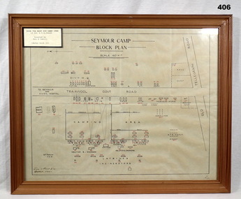 Bendigo Military Museum
Map - PLAN, FRAMED
... documents - maps/plans... for Service History also 2034P. documents - maps/plans military ...LT COL BENJAMIN THOMAS ROY CHADD No's 10594, VX20311, 1st and 2nd AIF. Refer 2039 for Service History also 2034P. Plan, detailing Seymour Camp Block Plan, Signals 7th Aust Div Camp 1940, re LT COL BENJAMIN THOMAS ROY CHADD. Tan coloured frame, glass front, cardboard backing, detail of camp layout, scale 160' = 1".documents - maps/plans, military history - army, frames -
 Bendigo Military Museum
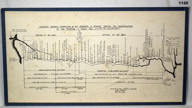
Map - DIAGRAM, MOUNTED
... documents - maps.... Refer 2485 for his service history. documents - maps military ...Item donated by Alf Maskell POW. Refer 2485 for his service history.Diagram showing construction of Burma-Siam railway. White background with black writing & markings. Mounted on blue board.Top centre: Diagram showing disposition of strength and others during construction of Burma - Siam Rly (Finished about Oct / Nov 1943)documents - maps, military history - pows -
 Bendigo Military Museum
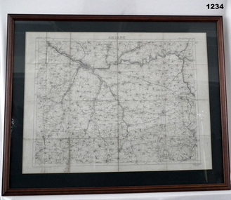
Map - MAP FRANCE, FRAMED, Ordinance Survey 1918, c.1918
... documents-maps... France 1:100,000 For Office Use Only documents-maps france frame ...Thin wooden frame with green border, glass front. Amiens,France. War Office October 1915.Amiens France 1:100,000 For Office Use Onlydocuments-maps, france, frame accessories, amiens -
 Bendigo Military Museum
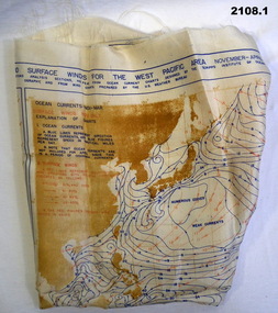
Equipment - LEATHER POUCH & CONTENTS, Naval Aviation Training Division, c.WWII
... documents - maps... in No 40 Operational Base unit. documents - maps costume ...Items relate to Clifford Alfred Cairncross, joined the RAAF on 4.6.1942 No 56931 age 28 years. At discharge on 16.4.1946 he held the rank of LAC in No 40 Operational Base unit..1) Map of ocean curents & surface winds west pacific area - on silk fabric (Nov - Apr). .2) Heliograph mirror & foresight, glass & metal with printed instructions on mirror back. .3) Cotton pouch to hold heliograph. .4) 1 Pair black leather large pilot's gloves .5) 1 Pair brown leather pilot's gloves .6) Aircraft recognition US Navy book .7) Brown leather document pouchdocuments - maps, costume accessories, glove accessories, communications - signals, containers, books - reference -
 Bendigo Military Museum
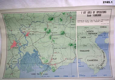
Map - MAPS, VIETNAM, April 1969
... documents - maps - military & tourist...:12,500 approx. documents - maps - military & tourist Vietnam .1 ...1.) Paper map, colour with black print, scale 1:500,000 area covers Saigon, Long Bin, Nui Dat, Vung Tau. .2) Laminated paper map showing city of Vung Tau with details of tourist destinations, hotels, churches, black & red print, scale 1:12,500 approx.documents - maps - military & tourist, vietnam -
 Bendigo Military Museum
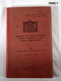
Manual - TRAINING MANUALS, 2), .3), & .4) Her Majesty's Stationery Office, Manual of Map Reading, Photo Reading, and Field Sketching, 1) 1929, Reprint 1939; .2) 1955; .3) 1957; .4) 1958
... documents - maps... history, technical documents - maps .1) His Majesty's Stationery ...Training Manuals - War Office London 1920 - 1939. .1) Red coloured cardboard with red coloured buckram, spine, black print on front & Coat of Arms. 166 pages, cut, plain, off white paper with black & white & coloured maps & diagrams. .2), .3) & .4) Red coloured cardboard with red coloured buckram, spine, black print on front. Cut, plain, off white paper with black & white & coloured maps & diagrams. .2) 132 pages. .3) 80 pages. .4) 69 pages. .1) “1929 Reprinted with amendments No's 1 to 4 1939” .2) “1955 Part 1 Map Reading” .3) “1957 Part III Field Sketching” Front fly leaf in red ballpoint pen: “S Sgt Moore / LAD” .4) “1958 Part II Air Photo Reading”books-military history, technical, documents - maps -
 Bendigo Military Museum
map - MAP, JAPANESE, C. 1930's
... documents - maps.... documents - maps military history Pearl harbour ...Map, Japanese, B&W, yellowed "Pearl Harbour". Japanese and English translation, Map No. 2015.documents - maps, military history, pearl harbour -
 Bendigo Military Museum
Map - DAEWIN MAP, FRAMED, 1938
... documents - maps... & glass front. Sketch Map of Darwin. documents - maps frame ...Wooden frame with green border & glass front.Sketch Map of Darwin.documents - maps, frame accessories, darwin -
 Bendigo Military Museum
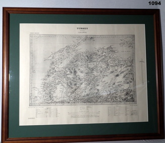
Map - MAP GALLIPOLI, FRAMED
... documents - maps..., Gallipoli. Rear: Bethany Gallery stamp. documents - maps military ...Brown, wooden frame with glass front, white cardboard backing, map mounted with green border. Map of Gallipoli area in black & light grey with white border. A detailed map of Turkey area around Dardanelles with references & scale charts at bottom. Reprinted for the Department of Defence, Commonwealth of Australia, May 1915.Front Top Centre: Turkey, Gallipoli. Rear: Bethany Gallery stamp.documents - maps, military history, gallipoli -
Tatura Irrigation & Wartime Camps Museum
Document, Geological Plan, Eildon Dam Site, 1945
... of Eildon water/irrigation documents maps ...To record details of geological aspects of EildonA series of maps illustrating rock formations etc., locations, boundaries and planswater/irrigation, documents, maps -
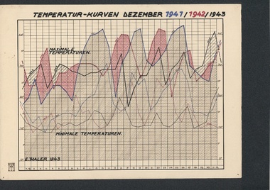 Tatura Irrigation & Wartime Camps Museum
Folio, Loveday & Camp 1 Temperature & Wind records, 1942-45
... in Camp 3, Tatura ww2 camp 3 loveday documents maps ...Records taken and graphed while in internment at Loveday and Tatura. Sketches and story were done in Camp 3, TaturaBlue plastic folder and sleeves containing 10 graphs, and nineteen coloured pen and ink and colour sketches and story of young children in Camp 3ww2 camp 3, loveday, documents, maps -
Clunes Museum
Map
... HISTORY DOCUMENTS MAPS MAPS ....1 - .4 DETAILED MAP OF CLUNES BY F.C.W. .5 MAP OF CLUNESlocal history, documents, maps, maps -
Clunes Museum
Document - SURVEYORS MAP, A.C.BROOKS. GOVERNMENT PRINTER MELBOURNE, 1937
... MAP Document NO.1 SURVEYORS MAP TALBOT AND SURROUNDING TOWNS ...NO.2 COPY OF NOTES TAKEN FROM DIARY 1865 THOUGHT TO BE WRITTEN BY JESSE HOARE SMITH WHO WAS A SURVEYOR AT CLUNES AT THE TIME. DIARY TURNED UP IN NORTH QUEENSLAND AND NOW IN POSSESSION OF A CRESWICK MAN.NO.1 SURVEYORS MAP TALBOT AND SURROUNDING TOWNS 1937. NO.2 DIARY NOTES 1865 THOUGHT TO BE WRITTEN BY JESSE HOARE SMITHlocal history, documents, maps, weickhardt, wattleworth -
Whitehorse Historical Society Inc.
Document, Particulars of maintainance works, 1933
... and Mitcham Financial documents Maps Burwood Road Healesville Road ...Shire of Blackburn and Mitcham - particulars of maintenance works carried out under the maintenance grant for the year ending 30 Jun 1933 and map showing work on the Main Healesville Road and Main Burwood Road.Shire of Blackburn and Mitcham - particulars of maintenance works carried out under the maintenance grant for the year ending 30 Jun 1933 and map showing work on the Main Healesville Road and Main Burwood Road.Shire of Blackburn and Mitcham - particulars of maintenance works carried out under the maintenance grant for the year ending 30 Jun 1933 and map showing work on the Main Healesville Road and Main Burwood Road.local government, shire of blackburn and mitcham, financial documents, maps, burwood road, healesville road, whitehorse road -
 Bendigo Military Museum
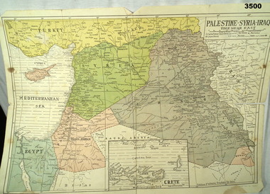
Map - MAP MIDDLE EAST, Dyag Press Ltd
... documents - maps... & Crete, countries involved in the war. documents - maps military ...Coloured map of Palestine, Syria, Iraq & Crete, countries involved in the war.documents - maps, military history, middle east -
Glen Eira Historical Society
Map - CAPLES PLACE SUBDIVISION
... Subdivisions Documents Maps Glen Eira CAPLES PLACE CAPLES PLACE ...This file contains a copy of a map of the CAPLES PLACE SUBDIVISION, undated and author unknown. The map provides the dimensions of roads and allotments in the area, including also handwritten notes from the original document and others written directly onto the copy.land subdivisions, documents, maps, glen eira, caples place, caples place subdivision, land surveys, orrong road, mulgrave road, prahran grove, somerset road, prahran grove, prahran grove, east walk, land allotments, town planning, garden road -
 Bendigo Military Museum
Accessory - MAP, TRENCH FRAMED
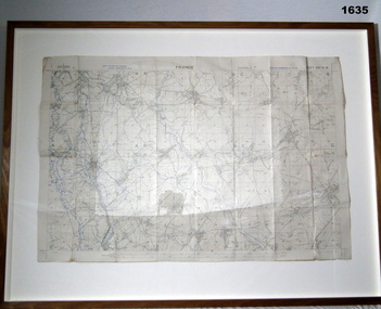
... documents - maps.... Refer 1634P for the story on the map. documents - maps frame ...Belonged to JOHN WILLIAM GRINTON No 1043 C Coy 38th Batt AIF. Refer Reg No 1280 for Service Details also 1317P, 1319P. Refer 1634P for the story on the map.Trench map of France - Edition 5A Bellicourt - Montbrahain - Bran Court. Tan, wooden frame, glass front with white cardboard backing. Hanging wire attached at back with centre strengthening brace. Map stuck on white background. German trenches in blue. Top middle: France. RHS bottom rear: The Union Studio - Castlemaine sticker.documents - maps, frame accessories, military history - army -
 Bendigo Military Museum
Map - MAPS, 1937
... documents - maps... No 215.9 for service history. documents - maps military equipment ...Items saved by Maurice Anthony BYRNE RAAF. Refer Cat No 215.9 for service history..1) map details on the map with biro lines marking the route taken by a traveller 1937 .2) map printed both sides Western New Guinea B6 December 1943 .3) map sheet B6 January 1944 top part of Australia .4) map Australia north plotting sheet .5) map C4 June 1943 .6) map Australian Aeronautical C5 June 1943documents - maps, military equipment -
 Bendigo Military Museum
Plan - MAP, TOURIST, L Joly, A Maunier, WWI
... documents-maps.... Refer 1317P, 1320P. documents-maps french "Plan commode de Paris ...The map belonged to Jack Grinton No 1043 38th Batt AIF. At Wars end extensive leave was granted, Jack journeyed to Paris, Nice, Monte Carlo taking many photos. Part of the Grinton collection which included hundreds of negatives and developed photos that he took during the War. Refer Cat No 1280 for service details. Refer 1317P, 1320P.Map of Paris. Red cardboard or paper hardcover, new edition guide of metropolitan Paris (ministries, tramways, monuments), Index in front, folded paper map attached to back cover. "Plan commode de Paris avec l'itineraire des autobus & tramways metropolitan"documents-maps, french -
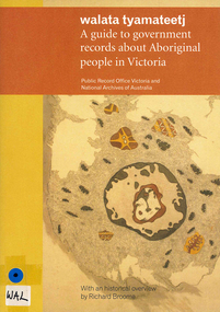 Victorian Aboriginal Corporation for Languages
Book, Public Record Office Victoria et al, Walata tyamateetj : a guide to government records about Aboriginal people in Victoria, 2014
... document reproductions, maps, b&w photographs... to find relevant records. document reproductions, maps, b&w ...Public Record Office Victoria and the National Archives of Australia hold many government records about Aboriginal people in Victoria. This guide is designed to help Victorian Aboriginal people find records about their family and country. It will also assist anyone researching the history and administration of Aboriginal affairs in Victoria to find relevant records.document reproductions, maps, b&w photographsarchives, archives directories, historical sources, public records, victorian history